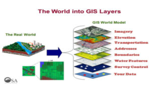
GIS is a system of computer software, hardware, data, and personnel to help manipulate, analyze and present information that is tied to a geographic location.
Geographic information system enables viewing, understanding, questioning, interpreting, and visualizing data in many ways that reveal relationships, patterns, and trends in the form of maps, globes, reports, and charts.
Many companies have a database management system in which day-to-day information is stored. If information has location attached to it, that information can be mapped. Using GIS, a business can unlock this spatial data and provide the perspective for the analysis needed to succeed. From the everyday business database GIS can represent
- Customer profiles by location, demography, and purchasing power
- Sales success by product, site, and sales representative.
- Site locations of stores, factories, and warehouses.
- Asset location (e.g., utility poles, pipes, and cables).
- Resource locations of staff, products, and equipment.
- Delivery routes by land, sea, and air.
 Utilized in natural and human- induced disasters, GIS has merged into the common operating procedures for public safety and emergency response activities.
 – In retail business to maintain information about sales, customers, inventory, demographic profiles, and mailing lists, all of which have geographic locations. Therefore, business managers, marketing strategists, financial analysts, and professional planners increasingly rely on GIS to organize, analyze, and present their business data.